NASA images show how the lake from ‘Planet of the Apes’ is drying up
Lake Powell, the second-largest reservoir in the United States, is suffering from the most extreme drought in centuries
/cloudfront-eu-central-1.images.arcpublishing.com/prisa/LLPQMQP26ZEFVIHIDTC7K2GQXM.jpg)

Lake Powell is the second-largest reservoir in the United States. Its construction began in 1956, after US president Dwight D. Eisenhower authorized its excavation. It opened in 1963, and it took 16 years to be filled with the waters of the Colorado River. Now, however, after three years of extreme drought and more than two decades of low rainfall, its waters are at its lowest level since it was built. The lack of water can be seen from the ground, but satellite images just released by NASA show the full scale of the drought.
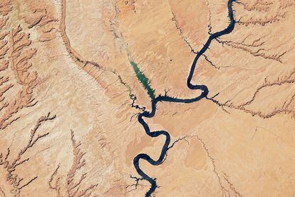
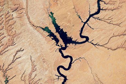
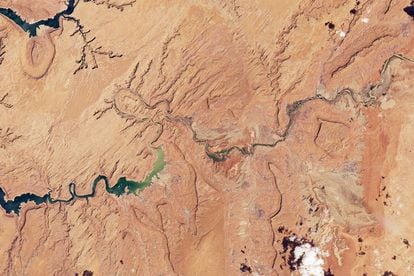
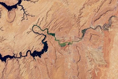
The satellite images capture the main part of the enormous Lake Powell and parts of the Bullfrog and Castle Butte areas of the Colorado River, as well as the basin of the San Juan River, a tributary that comes from the east and which is also part of the reservoir. Lake Powell and the Colorado River are a tourist attraction, but the drought is affecting the lake’s recreational use. Due to its distinctive landscape, part of the movie Planet of the Apes was filmed on Lake Powell: it is the landing spot for the astronauts who have traveled back in time and believe they are on another planet. Many of the exterior scenes of the film were filmed in the area.
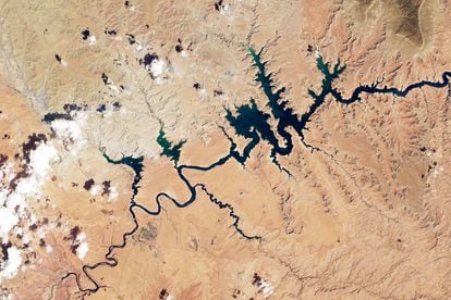
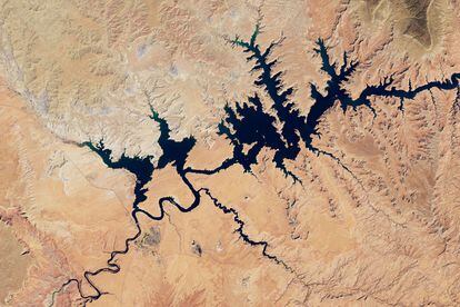
Lake Powell straddles the border of southeastern Utah and northeastern Arizona. Most of the NASA images show the Utah portion. The color photos released this week by NASA were taken by Landsat satellites and show parts of Lake Powell in the months of August 2017 and 2022. The researchers chose 2017 because it was one of the wettest periods of the past decade. Even that year, though, the level was well below that of 2000, the year that began a long and relentless drought.
On August 16, 2017, the water level in the lake, measured at Glen Canyon Dam, was 3,633.04 feet (1,107 meters). On August 6, it stood at 3,535.38 feet, almost 98 feet lower. That represents just 26% of the reservoir’s capacity, its lowest point since it what was built. What’s worse, the water is dangerously close to 3,490 feet, the red line at which hydroelectric generation is no longer viable, since it falls below the level at which the turbines can work properly.
The worst drought in centuries
Downstream from Lake Powell lies Lake Mead, the largest reservoir in the United States. Its situation is no better. As of August 22, it is currently at 28% of its capacity. The entire southwestern United States is experiencing an unprecedented drought. Two years ago, an article in the journal Science said that the dry spell, which started in 2000, was the most severe since the end of the 16th century and the second longest since the 9th century. The situation has only gotten worse.
The Federal Bureau of Reclamation announced last week restrictions on the volume of water destined for Arizona, Nevada and Mexico, in the lower basin of the river. The announced cuts, which take effect in 2023, mean that Arizona will receive 21% less water from Lake Mead, with a cut of about 730 million cubic meters. Nevada will have an 8% reduction of 31 million cubic meters, and Mexico will receive a 7% cut, of 128 million cubic meters.
The Colorado River, about 1,400 miles long, is the fifth-longest river in North America. Its basin extends through the states of Wyoming, Colorado, Utah, New Mexico, Arizona, California and Nevada plus northwestern Mexico. It begins in La Poudre Pass, a small town located at 3,100 meters above sea level in the Rocky Mountains, in the north of the state of Colorado. Upon arrival in Mexico, it forms the border between Baja California and Sonora and flows into the Gulf of California, or the Sea of Cortez, in the Pacific Ocean.
Its watershed provides electricity and water to approximately 40 million people, in particular the cities of Las Vegas, Phoenix, Los Angeles and San Diego, and to millions of hectares of farmland in the southwest.
/cloudfront-eu-central-1.images.arcpublishing.com/prisa/ASU7DMF5CNIJ4K5SIPNXEJUJNQ.jpg)
/cloudfront-eu-central-1.images.arcpublishing.com/prisa/YUHVSMS2IN6DXD4JXSVFSTJ4WI.jpg)